Along the southern shore of Lake Superior, in Michigan's Upper Peninsula, one thing is certain; all things flow to "Gitche Gumee", Longfellow's interpretation of the Ojibwa name for Lake Superior in The Song of Hiawatha. Couple this flow of water with rugged terrain, and you will understand why Alger County is scattered with incredible waterfalls.

Photo by Kathryn Lund Johnson
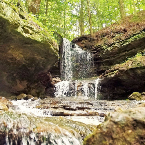
Laughing Whitefish Falls
Laughing Whitefish Falls is one of Michigans best waterfalls, where its namesake stream plunges over a lip and then cascades down literally hundreds of tiny stairstep ledges of a bulbous layered sandstone formation.
Height: 100ft
Water Source: Laughing Whitefish River
Coordinates: 46.3837, -87.0689

Photo by Kathryn Lund Johnson
Rock River Falls
This wild waterfall is hidden in the Rock River Wilderness Area north of Chatham. Reaching it will require you to drive down some old logging roads and hike a mile or two along some ill defined trails, but if you are looking for a good waterfall adventure it is worth it.
Height: 20ft
Water Source: Rock River
Coordinates: 46.4113, -86.9759

Photo by Kathryn Lund Johnson
Au Train Falls
A pair of waterfalls conveniently located right off the highway between Munising and Laughing Whitefish Falls.
Height: 30ft
Water Source: Au Train River
Coordinates: 46.33591, -86.85110

Photo by Kathryn Lund Johnson
Scott Falls
Scott Falls is a small roadside waterfall. It is 10 miles west of Munising on M-28. The falls is a single 10 foot drop. There is a small park by the falls. Even on a rainy day in the spring the falls does not have a lot of water.
Height: 12ft
Water Source: Scott Creek
Coordinates: 46.4378, -86.814

PHOTO BY KATHRYN LUND JOHNSON
Wagner Falls
Wagner Falls is located south of Munising, on the east side of MI-94 just south of the MI-28 MI-94 junction. It has its own state park. There is small parking area and a sign. A short boardwalk leads to the falls. It is a pleasant walk and a pretty waterfall.
Height: 20ft
Water Source: Wagner Creek
Coordinates: 46.3877, -86.6465

PHOTO BY KATHRYN LUND JOHNSON
Alger Falls
This is a small roadside waterfall just outside of Munising. Worth a quick look when it has water. By mid summer it gets pretty thin.
Height: 20ft
Water Source: Alger Creek
Coordinates: 46.3932, -86.6479
Horseshoe Falls
Horseshoe Falls is a scenic, privately owned waterfall in Munising. There is an admission fee to visit the falls. It is spring fed, so it may be flowing when the other five falls in the area are not.
Height: 20ft
Water Source: Unnamed Creek
Coordinates: 46.4029, -86.6427

PHOTO BY KATHRYN LUND JOHNSON
Tannery Falls
NOTICE- Tannery Falls are closed to the public at this time.
This is a largely unadvertised waterfall hidden away in Munising. It is not as big as Munising Falls, but if you are in the area and have the time, stop by and visit.
Height: 40ft
Water Source: Tannery Creek
Coordinates: 46.4158, -86.6269

Photo by Kathryn Lund Johnson
Memorial Falls (Monument Falls)
NOTICE- Memorial Falls are closed to the public at this time.
This is a pretty waterfall in a pretty gorge, but with limited water flow.
Height: 40ft
Coordinates: 46.4173, -86.6273

PHOTO BY KATHRYN LUND JOHNSON
Munising Falls
This is a pretty waterfall and it is easy to visit.
Height: 75ft
Water Source: Munising Creek
Coordinates: 46.4227, -86.6213

Photo by Larry Baur
Miners Falls
After Munising Falls this is the most accessible of the Pictured Rocks waterfalls. It is an impressive waterfall and easy to get to.
Height: 35ft
Water Source: Miners Creek
Coordinates: 46.4746, -86.5315

Photo by Larry Baur
Bridal Veil Falls
This tall, seasonal waterfall is best seen from the water. It is one of the many sights on the Pictured Rocks boat cruise, which is worth while even if this falls has little or no water. It can also be seen while hiking along the shore.
Height: 140ft
Water Source: Unnamed Creek
Coordinates: 46.5087, -86.5233

Mosquito Falls
Mosquito Falls is a small waterfall consisting of two main drops about 100 meters apart with a stretch of rapids in between them. The lower drop is about 10 feet high, and the upper one is about 5 feet high. This is the smallest of the named Pictured Rocks waterfalls but it is a very lovely hike, especially in spring when the flowers are out.
Height: 13ft
Water Source: Mosquito River
Coordinates: 46.5162, -86.4778
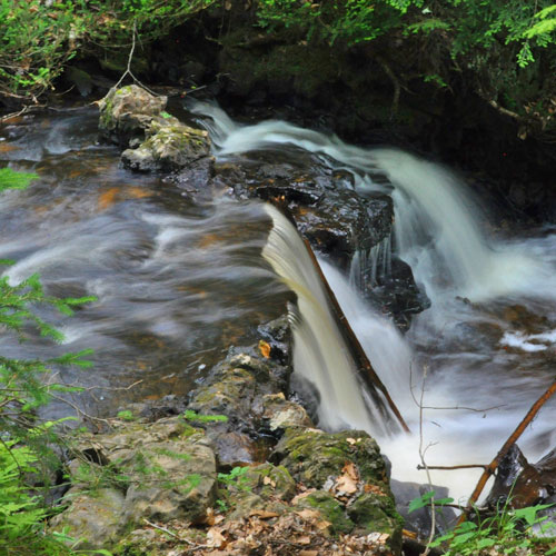
PHOTO BY KATHRYN LUND JOHNSON
Chapel Falls
This is a mostly wild waterfall located in Pictured Rocks Backcountry and must be hiked to.
Height: 60ft
Water Source: Section Creek
Coordinates: 46.5289, -86.4443

Photo by Craig Blacklock
Spray Falls
This remote and impressive waterfall plunges directly into Lake Superior. It can be seen from the Lakeshore Trail, requiring at least a two mile hike one way.It is best viewed from the lake.
Height: 70ft
Water Source: Spray Creek
Coordinates: 46.558, -86.4105

PHOTO BY KATHRYN LUND JOHNSON
Sable Falls
Sable Falls is located in Pictured Rocks National Lake Shore, at the east end of the park a few miles west of Grand Marais on H-58. It is only a half mile walk from the parking area to the falls. These falls are interesting because they are surrounded by sand dunes.
Height: 35ft
Water Source: Sable Creek
Coordinates: 46.6678, -86.0145